
Marine / Nautical Publication
General Chart of Terra Australis
General Chart of Terra Australis
Description
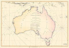
The General Chart of Terra Australis, or Australia, showing the parts explored between 1798 and 1803 by Matthew Flinders in HMS Investigator.
It is the first chart to show the continent is in entirety and the first document to use the word "Australia" to describe the continent.
This map was first published in 1814. This version was updated to include some additional information up to 1822.
We present this map printed on canvas for hanging of stretching in A0 print size (hangers and/or frame not included).
Locations within this Map
Savu Flores Gilbert Sulawesi Selatan Sulsel Indonesia Ambeno Ambino Oecussi East Timor