
QLD 6560
QLD 6560
Digital Products: You will receive an email shortly after checkout containing links to download your products.
If you do not receive this email within 30min, please check your Junk / SPAM email folder, prior to contacting us.
Description
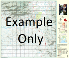
This Topographic Map is produced by the Department of Natural Resources and Mines (DNRM), part of the Queensland Government.
This product is continously updated with the latest information available. New editions are generally published in Oct/Nov each year, however minor updates are constantly being included.
DNRM maps are produced automatically by computers, with minimal human oversight; so some duplication of information and occasional minor cartographic inconsistencies can be found.
The PDF version of this can be printed at home or sent to a professional printer for a 100% scale reproduction.
At this scale, 1cm on this map represents 1km on the ground. A standard map (which is square) covers an area of approximately 54km by 54km, with a contour interval of 20m. This map contains natural and constructed features including road and rail infrastructure, vegetation, hydrography, contours, localities and some administrative boundaries.
New Herbert Vale Beeny Black Spring Bunbay Bymbell Carrara Creek Colless Creek Constance Range Coolibah Creek Doherty Creek Don Creek Edith Spring Garden Spring Gorge Creek Gorge Creek Spring Grass Creek Highland Plains Holts Creek Hut Creek Littles Range Milcree Mullera Murrays Creek Murrays Spring Old Herbert Vale Palting Pidna Ribbon Creek Ridgepole Waterhole Shadforth Spring Tidna Wilfred Lawn Hill Gorge Mouth Resources Reserve Lawn Hill Stockyard Creek Resources Reserve Lawn Hill Mount Isa City Boodjamulla Lawn Hill National Park Constance Ridge Musselbrook Mining Camp Rift Creek The Rift Herbert Vale Bellbird Creek Barkly Tableland Barklay Table Land