
QLD 6660
QLD 6660
Digital Products: You will receive an email shortly after checkout containing links to download your products.
If you do not receive this email within 30min, please check your Junk / SPAM email folder, prior to contacting us.
Description
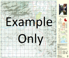
This Topographic Map is produced by the Department of Natural Resources and Mines (DNRM), part of the Queensland Government.
This product is continously updated with the latest information available. New editions are generally published in Oct/Nov each year, however minor updates are constantly being included.
DNRM maps are produced automatically by computers, with minimal human oversight; so some duplication of information and occasional minor cartographic inconsistencies can be found.
The PDF version of this can be printed at home or sent to a professional printer for a 100% scale reproduction.
At this scale, 1cm on this map represents 1km on the ground. A standard map (which is square) covers an area of approximately 54km by 54km, with a contour interval of 20m. This map contains natural and constructed features including road and rail infrastructure, vegetation, hydrography, contours, localities and some administrative boundaries.
Lawn Hill Adels Grove Bellbird Creek Bulmung Cattle Creek Coglan Creek Deep Creek Dinner Creek Edith Range Fort William Freemans Creek Garden Spring Gregory Hetzer Creek Hetzer Waterhole Horse Creek Hunter Waterhole Kamarga Mount Kay Keble Lily Creek Lilydale Lilydale Spring Little Archie Creek Little Creek Louie Creek Marys Waterhole Mebbon Mended Hill Mitton Creek Napoleon Bonnet O'Shanassy River Page Creek Police Creek Rankins Creek Rankins Plain Rankins Yard Spring Creek Stony Creek Ten Mile Waterhole Tyum Verdon Creek Verdon Rock Wangunda Wangunda Creek Wangunda Plain Lawn Hill Creek Resources Reserve Lawn Hill Lilydale Resources Reserve Stoney Creek Napoleons Bonnet Mary Waterhole Pear Creek Edith Spring Silver Star Mine Rankin Creek Carl Creek OShanassy River