
QLD 6852
QLD 6852
Digital Products: You will receive an email shortly after checkout containing links to download your products.
If you do not receive this email within 30min, please check your Junk / SPAM email folder, prior to contacting us.
Description
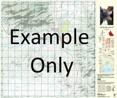
This Topographic Map is produced by the Department of Natural Resources and Mines (DNRM), part of the Queensland Government.
This product is continously updated with the latest information available. New editions are generally published in Oct/Nov each year, however minor updates are constantly being included.
DNRM maps are produced automatically by computers, with minimal human oversight; so some duplication of information and occasional minor cartographic inconsistencies can be found.
The PDF version of this can be printed at home or sent to a professional printer for a 100% scale reproduction.
At this scale, 1cm on this map represents 1km on the ground. A standard map (which is square) covers an area of approximately 54km by 54km, with a contour interval of 20m. This map contains natural and constructed features including road and rail infrastructure, vegetation, hydrography, contours, localities and some administrative boundaries.
Waterford Scarsdale Stockport Badalia Wirrilyerna Montagu Downs Boulia Alderley Bedrule Bengeacca Creek Bengeacca Water Facility Bengeacca Waterhole Blair Athol Bloodwood Waterhole Boomerang Waterhole Boulia Waterhole Boundary Lagoon Claypan Waterhole Craigies Lagoon Donohues Creek Edges Creek Gawsworth Gidya Creek Goodwood Gum Creek Hartnell Horse Creek Hurley Inkey Waterhole Jibloo Waterhole Limestone Creek Longsight Peak Loxa Maryvale Mosquito Creek Native Well Waterhole Nine Mile Creek Nisbet Water Facility Peak Creek Plum Pudding Waterhole Policeman Waterhole Prices Creek Shepleys Lagoon Six Mile Creek Wills Windburg Plain Gregory North Mucklandama Creek Maryvale Bore Loxa Number Two Bore Montagu Downs Bore Badalia Number Two Bore