
QLD 6855
QLD 6855
Digital Products: You will receive an email shortly after checkout containing links to download your products.
If you do not receive this email within 30min, please check your Junk / SPAM email folder, prior to contacting us.
Description
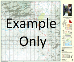
This Topographic Map is produced by the Department of Natural Resources and Mines (DNRM), part of the Queensland Government.
This product is continously updated with the latest information available. New editions are generally published in Oct/Nov each year, however minor updates are constantly being included.
DNRM maps are produced automatically by computers, with minimal human oversight; so some duplication of information and occasional minor cartographic inconsistencies can be found.
The PDF version of this can be printed at home or sent to a professional printer for a 100% scale reproduction.
At this scale, 1cm on this map represents 1km on the ground. A standard map (which is square) covers an area of approximately 54km by 54km, with a contour interval of 20m. This map contains natural and constructed features including road and rail infrastructure, vegetation, hydrography, contours, localities and some administrative boundaries.
Ashover Butru Valley Dronfield Alligator Creek Bakewell Birds Creek Birdwell Black Mountain Blaze Creek Bottletree Hummock Boundary Hill Bungalien Bushy Park Butru Capsize Creek Chatsworth Clement Creek Colonsay Dingo Creek Duchess Duff Creek Mount Erle Flynn Green Creek Mount Guide Juenburra Kurbayia Lament Creek Little Burke River Mairindi Creek Malbon Vale Maud A Gate Mayfields McPhee McPhee Creek McPhee Hills Mecca Creek Mickory Waterhole Mimosa Creek Myubee Newbold Mount Philp Pilgrim Gate Pintpot Creek Plum Mountain Powell Quartpot Creek Quarts Creek Quartz Creek Razorback Creek Rogica Creek Shinfield Creek Smith Creek Teddington The Brothers Trekelano Wandolbie Waterhole Willinga Waterhole Woobera Woonigan Yarraman Creek Mount Philip Smith Creek Well Kabayah Kennedys Well Mount Hope The Salt Well Boundary Bore Teddington Lock New Six Mile Bore Dronfield Well Burke River Well Quartpot Bore Peum Mountain