
Land Parcels and Analysis of Proximities
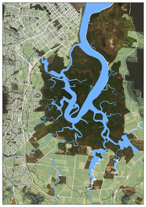
For those living in Cairns, Admiralty Island at the center of this map, is an unmistakable shape.
This map was requested for a planning purposes. The customer required to see roads, land tenure, topographic contours and water lines all together.
We then conducted some further proximity analysis to identify certain areas within the scope of the map that fit particular criteria (ie: a certain height above sealevel, a certain distance from any residential house, not further than a particular distance from a road).
The outcome was a series of focused regions which fit the clients requirements.
