
Hekili Ocean Challenge
We were asked by the local Outrigger Club to draw up a course map for their annual ocean race.
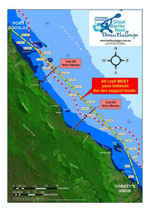
Using our data sets, some satellite imagery and way points from the client, we put together this great little map.
The client wanted to really show off the MacAlister Ranges - that they would be rowing up a very heavily forested and spectacular coastline.
They also needed to represent some safety information like the 2nm EPIRB line, safety boat locations and time cut offs.
We also included 15min "latest time" markers - so they could monitor the progress of teams and give them warning if they wouldn't make the finish within the time frame.
The map was print in various sizes and displayed online for teams to study.
