
Policy Area for Marine Insurer
Here is an example of some basic geospatial analysis being put to use to support a Marine Insurer in conveying to their customers the extents of the varies policy areas.
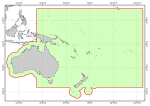
The policy included statements such as "200nm from Australian or New Zealand Territory", and then a series of Coordinates boxing in the policy area.
What was interesting was that "200nm from Australia" implied that places like Christmas Island were "included", however as Christmas Island is well over 1000nm from Australia, it would not be possible to reach the 200nm "zone" off that Island, without first leaving (and thus breaching) the policy.
This however is not the case with some of the off lying islands of New Zealand, which are closer than 400nm from the mainland, and thus their buffers (the correct geospatial term) overlap.
This was as much an interesting insight for the Insurer as it was clarification to their customers.
