
Satellite Imagery, Land Boundaries and Topography
Sometimes it is easiest to have all the info in the one place - and that is exactly what geospatial services can help with.
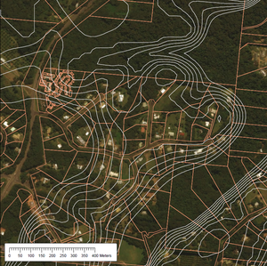
Here we have an example of high-res satellite imagery, overlaid with property boundaries, overlaid again with topographic elevation contours.
This can be taken further by using a 3D modelling approach and draping the imagery and property boundaries over the elevation model. With a good XYZ Geospatial Model, we can determine:
- How the Sun will interaction with a building or surface
- View sheds and line of sights - what can be seen from a position, or what can see a position (important for Radio towers for example)
- Watershed and run off
- Estimate fill or excavation amounts
- Determine 3D distances (ie: a pipe running uphill is going to be longer than the distance measured on the plane - over even a small elevation it can be a significant difference)
