
AUS 23
Apsley Strait (Southern Sheet)
Please note that all charts are nominally folded in half for storage and handling as per the marine industries standard.
If you require an unfolded copy (ie: flat for framing), please select Flat Paper, and we will organise a special print service to accomodate your request.
Description
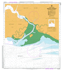
This official Nautical Chart is produced by the Australian Hydrographic Office, and corrected fortnightly to 'Notice to Marines' by Cairns Charts & Maps. This ensures it remains compliance with Safety of Navigation requirements. This marine chart, or 'sea map', is primarily produced to support the safe navigation of commercial shipping through Australian, Papua New Guinea and Solomon Island waters.
Nautical charts depict the seabed, or bathymetry, using a variety of colours to shade the depth regions. Darker blues indicate shallower water, while light blues and white indicate deeper water. A chart will also show continuous contour lines (at varying intervals depending on the scale of the chart), 'spot depths' across the whole area, as well as different symbols indicating wrecks, shallow rocks and dangers, as well as details on lights, light houses, tides and currents.
For extensive detail on the symbology of nautical charts, the Symbols and Abbreviations used on Admiralty Charts is the definitive reference.
Nguiu Bathurst Island Airfield 4 Mile Camp Bathurst Island Barge Landing Buchanan Island Cockle Point Marralayangimpi Creek Maruru Point Medina Inlet Mintiluwu Creek Mirrapoka Creek Mission Hill Nguiu Community Health Centre Nguiu Police Station Paru Pekiapauthera Creek Pirapillipoonga Creek Pramamee Creek Purninga Point Shoal Bay Takamprimili Creek Tamratoarimu Creek Taradiri Creek Tominappi Creek Wanyanga Beach Wirrianappi Creek Tipabina Creek Morriu Point Mindelu Creek Mirialampi Creek Waniunga Beach Buchanan Islets