
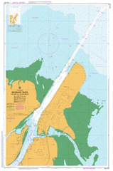
AUS 237
The Bar To Lytton Reach
Please note that all charts are nominally folded in half for storage and handling as per the marine industries standard.
If you require an unfolded copy (ie: flat for framing), please select Flat Paper, and we will organise a special print service to accomodate your request.
Description
This official Nautical Chart is produced by the Australian Hydrographic Office, and corrected fortnightly to 'Notice to Marines' by Cairns Charts & Maps. This ensures it remains compliance with Safety of Navigation requirements. This marine chart, or 'sea map', is primarily produced to support the safe navigation of commercial shipping through Australian, Papua New Guinea and Solomon Island waters.
Nautical charts depict the seabed, or bathymetry, using a variety of colours to shade the depth regions. Darker blues indicate shallower water, while light blues and white indicate deeper water. A chart will also show continuous contour lines (at varying intervals depending on the scale of the chart), 'spot depths' across the whole area, as well as different symbols indicating wrecks, shallow rocks and dangers, as well as details on lights, light houses, tides and currents.
For extensive detail on the symbology of nautical charts, the Symbols and Abbreviations used on Admiralty Charts is the definitive reference.
Ampol Siding Boat Passage Boggy Creek Brisbane River Bulwer Island Clara Rock Clunie Flats Crab Creek Fisherman Islands Francis Channel Jubilee Creek Juno Point Luggage Point Lytton Hill Myrtletown Oyster Point South Point Tingal Hill West Banks Whyte Island Wynnum Creek Fort Lytton National Park Old Bar Cutting Quarantine Flats Reach Lytton Port of Brisbane Pinkenba Outer Bar Reach Outer Bar Cutting Serpentine Creek Koopa Channel East Banks Inner Bar Cutting Fisherman Point Dredge Spoil Bank Bishop Island Patrick Wharf Myrtle Saint Helena Island Middle Banks Luggage Point Cutting Uniacke Point Lower Reach White Island Pelican Banks Reach Pelican Bank Cutting Lytton Rocks Reach Lytton Rocks Cutting Ampol Wharf Upper Lytton Cutting Lytton Reach Bulwer Wall Lytton Cutting Swing Basin Swing Basin Reach Reformatory Hill Lytton Wall Wynnum North