
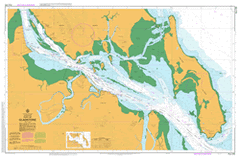
AUS 245
Port Of Gladstone
Please note that all charts are nominally folded in half for storage and handling as per the marine industries standard.
If you require an unfolded copy (ie: flat for framing), please select Flat Paper, and we will organise a special print service to accomodate your request.
Description
This official Nautical Chart is produced by the Australian Hydrographic Office, and corrected fortnightly to 'Notice to Marines' by Cairns Charts & Maps. This ensures it remains compliance with Safety of Navigation requirements. This marine chart, or 'sea map', is primarily produced to support the safe navigation of commercial shipping through Australian, Papua New Guinea and Solomon Island waters.
Nautical charts depict the seabed, or bathymetry, using a variety of colours to shade the depth regions. Darker blues indicate shallower water, while light blues and white indicate deeper water. A chart will also show continuous contour lines (at varying intervals depending on the scale of the chart), 'spot depths' across the whole area, as well as different symbols indicating wrecks, shallow rocks and dangers, as well as details on lights, light houses, tides and currents.
For extensive detail on the symbology of nautical charts, the Symbols and Abbreviations used on Admiralty Charts is the definitive reference.
Gladstone Southend Auckland Auckland Creek Auckland Hill Auckland Inlet Auckland Point Auckland Point Reef Barney Point Biondello Birkenhead Boat Creek Boatshed Point Briffney Creek Bushy Island Byellee Callemondah Calliope Calliope River Camp Island Carthurbie Creek Casuarina Clump Chinaman Island Clinton Clinton Park Clyde Creek Compigne Channel Compigne Island Curtis Datum Point Diamantina Island East Point East Point Ledge Endfield Creek Facing Channel Facing Island Farmers Point Farmers Reef Fishermans Landing Friend Point Garden Island Gatcombe Gatcombe Channel Gatcombe Head Golding Grass Point Grayson Hamilton Point Hay Island Hetherington Kin Kora Creek Laird Point Main Channel Manning Reef Mount Martin Middle Bank Mina Rock Mount Miller Mud Island North Bank North Channel North Entrance North Point Northcliffe Nutmeg Gully Observation Point Oyster Rock Parana Parsons Point Passage Islands Pearl Ledge Pelican Banks Permean Point Picnic Island Police Creek Pyealy Pyealy Creek Quoin Channel Quoin Island Randalls Landing Rat Island Rich Rocks Ripple Rock Rock Point Rocky Glen Rocky Point Roma Rock Round Hill Sable Chief Rocks Settlement Point She Oak Island Ship Hill Shoal Bay South Trees Island South Trees Point Tail Point Tide Island Tigalee Creek Turtle Island View Hill Wapentake Creek Watson Wiggins Islands Witt Island Auckland Channel South Gladstone Garden Island Conservation Park Panorama Point Calliope Conservation Park Gladstone Central Gladstone Harbour Kin Kora New Auckland South Trees Sun Valley Telina Toolooa West Gladstone Friends Point Graham Creek Grahams Creek Rawbelle Creek Rat Islet Southend Jetty Rich Hill Southend Channel Chinaman Islet Farmer Point South Passage Island Passage Island Fishermans Landing Wharf Targinie Channel Turtle Islet Passage Spit Ripple Reef Tide Islet Mud Islet Permian Point Permein Point Teningie Creek Clinton Channel Middle Banks Clinton Wharves Wiggins Islet Wiggins Islets Auckland Point Wharves Rich Rock Bushy Islet Barney Point Wharf Welby Creek South Trees Anchorage South Trees Wharf Boyne Valley Junction One Tree Hill South Trees Inlet South Tree Inlet