
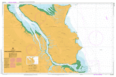
AUS 259
Hinchinbrook Channel
Please note that all charts are nominally folded in half for storage and handling as per the marine industries standard.
If you require an unfolded copy (ie: flat for framing), please select Flat Paper, and we will organise a special print service to accomodate your request.
Description
This official Nautical Chart is produced by the Australian Hydrographic Office, and corrected fortnightly to 'Notice to Marines' by Cairns Charts & Maps. This ensures it remains compliance with Safety of Navigation requirements. This marine chart, or 'sea map', is primarily produced to support the safe navigation of commercial shipping through Australian, Papua New Guinea and Solomon Island waters.
Nautical charts depict the seabed, or bathymetry, using a variety of colours to shade the depth regions. Darker blues indicate shallower water, while light blues and white indicate deeper water. A chart will also show continuous contour lines (at varying intervals depending on the scale of the chart), 'spot depths' across the whole area, as well as different symbols indicating wrecks, shallow rocks and dangers, as well as details on lights, light houses, tides and currents.
For extensive detail on the symbology of nautical charts, the Symbols and Abbreviations used on Admiralty Charts is the definitive reference.
Cardwell Lucinda Agnes Island Anchorage Point Mount Arthur Scott Barra Castle Hill Benjamin Flats Bishop Peak Blady Grass Creek Bluewater Creek Boulder Creek Boulder Hill Mount Bowen Bridge Creek Broken Pole Creek Mount Burnett Cadillah Creek Mount Cadillah Calka Cement Creek Channel Rock Clarkson Creek Combo Conn Conn Creek Dalrymple Gap Damper Creek Damper Hill Delta Creek Deluge Inlet Mount Diamantina Duncan Bluff Dungeness Dungeness Harbour Ellerbeck Elphinstone Creek Enterprise Channel Eva Island Fisher Creek Fisherman Point Five Mile Creek Gayundah Creek George Point Goddard Range Greenwood Hill Hay Creek Haycock Island Hecate Point Hillock Point Hinchinbrook Channel Hinchinbrook Island National Park Hinchinbrook Island Jocks Lodge Kirkville Hills Knoloban Laurence Creek Mount Leach Leefe Peak Lucinda Point Mailborree Mangrove Island Mangrove Point Manor Creek Mary Creek Mendel Creek Meunga Creek Missionary Bay Morris Creek Mount Elphinstone Range Muddy Creek Mullers Creek Mulligan Bay Nelson Creek Newman Creek Nina Peak One Mile Creek Oyster Point Oyster Rock Pagalla Paluma Creek Parra Petermun Springs Picnic Beach Pig Creek Pitt Mount Pitt Plunkett Creek Porter Creek Post Office Creek Ramsay Bay Ranko Reis Point Rocky Point Round Hill Sandstone Creek Scraggy Point Scrubby Creek Seymour River Slopeaway Stony Creek Straloch Mount Straloch Sunday Creek Takalgee Thangi The Haven The Thumb Tide Gauge Island Trevor Creek Two Mile Creek Twoagarra Waterfall Creek Weelkan Mount Westminster Abbey Wilkin Hill Zoe Bay Dalrymple Creek Hinchinbrook Channel National Park Abergowrie State Forest Cardwell State Forest Hinchinbrook Rungoo Eva Islet Port Hinchinbrook Port of Hinchinbrook Leafe Peak Creek Leafe Peak Mount Slopeaway Bishops Peak Neames Creek Seaforth Channel Seaforth Entrance Long Pocket Mount Cudmore Herbert River