
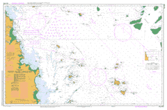
AUS 823
Percy Isles To Mackay
Please note that all charts are nominally folded in half for storage and handling as per the marine industries standard.
If you require an unfolded copy (ie: flat for framing), please select Flat Paper, and we will organise a special print service to accomodate your request.
Description
This official Nautical Chart is produced by the Australian Hydrographic Office, and corrected fortnightly to 'Notice to Marines' by Cairns Charts & Maps. This ensures it remains compliance with Safety of Navigation requirements. This marine chart, or 'sea map', is primarily produced to support the safe navigation of commercial shipping through Australian, Papua New Guinea and Solomon Island waters.
Nautical charts depict the seabed, or bathymetry, using a variety of colours to shade the depth regions. Darker blues indicate shallower water, while light blues and white indicate deeper water.A chart will also show continuous contour lines (at varying intervals depending on the scale of the chart), 'spot depths' across the whole area, as well as different symbols indicating wrecks, shallow rocks and dangers, as well as details on lights, light houses, tides and currents.
For extensive detail on the symbology of nautical charts, the Symbols and Abbreviations used on Admiralty Charts is the definitive reference.
Tedlands Ilbilbie Campwin Beach Blacks Beach Bucasia Eimeo Grasstree Beach Half Tide Beach Hector Mackay Sarina Sarina Beach Shoal Point Greenhill Grasstree Koumala Armstrong Beach Alarm Reef Alexandra Reefs Alligator Creek Alligator Waterholes Allom Point Andergrove Apsley Creek Arrowroot Creek Bailey Islet Bakers Creek Bally Keel Barnes Creek Basin Creek Bassett Basin Bassett Creek Mount Bassett Bates Rock Battle Bay Beaver Shoal Bedwell Group Bell Creek Bells Creek Beverlac Island Beverley Beverley Group Billy Rock Black Mountain Blackbird Shoal Mount Blarney Bluff Island Blunt Bay Boat Islet Bone Creek Boomerang Creek Borstal Mountain Breens Creek Breens Crossing Bull Creek Bulls Head Bluff Bushy Islet Bushy Island National Park Cab Creek Cabbage Tree Creek Calliope Island Cameron Creek Cape Creek Cape Palmerston National Park Castrades Inlet Cattle Creek Cattle Mountain Charles Rock Chase Point Mount Chelona Cherry Tree Creek Chevy Shoal Mount Christian Clump Hill Coalters Creek Coaster Channel Cockatoo Hill Coconut Point Cone Creek Cone Hill Connor Island Mount Convenient Coral Point Cremorne Cullen Island Cullen Reef Curlew Island Cutlack Island Mount Cutlack Cyclone Waterholes Daintry Creek Dalrymple Bay Dalrymple Loop Dangerous Reef Dawlish Dawson Beach Dawson Creek De Costa Bluff Deception Inlet Deep Creek Dents Mountain Derwent Island Devil Flat Creek Digby Island Dinner Island Dolphin Heads Double Island Douglas Island Downward Patches Duck Hole Creek Dudgeon Ledge Dudgeon Point Duff Creek Dunnrock East Point East Spur Edwards Shoal Eimeo Creek Elamang Islet Elizabeth Creek Emily Patches Emu Creek Ethel Sand Fairfax Rock Ferdinand Shoal Festing Shoal Figtree Beach Figtree Point Fishermans Point Flat Top Island Four Mile Beach Foxs Gap Freddy Creek Freshwater Point Frog Creek Mount Funnel Fursden Creek Gap Creek George Island Gillinbin Creek Glendower Point Glenella Goosepond Creek Graf Rock Green Hill Green Island Green Swamp Creek Grendon Creek Mount Griffiths Guardfish Cluster Mount Haden Half Tide Hall Creek Harry Shoal Hatfield Hatfields Gap Hay Point Hay Point Harbour Hay Point Port Hay Reef Heath Shoals Mount Hector Henani Rock Henderson Island Hesket Rock Highwater Island Hildebrand Rock Hirst Island Hixson Islet Hixson Point Hogans Camp Island Hotspur Islets Howard Howard Islet Howard Point Hull Island Hutchison Shoal Illawong Ince Bay Innes Island Inneston Irving Island Jack Rock Jackson Creek Jilalan Mount Jones Jordan Creek Joseph Bay Karremal Keelan Island Kelly Creek Kelvin Kemmis Kilgour Shoal Knight Island Knobler Creek Koota Koumala South Lamberts Beach Lantana Creek Leeper Reef Leichhardt Creek Little Daintry Creek Little Station Creek Llewellyn Bay Llewellyn Shoal Lloyd Shoal Loloma Long Hill Louisa Creek Lower Rock Mackay Harbour Mackay Point Main Camp Creek Marion Creek Marion Rock Marklands Creek Marsh Reef Marton McCreadys Creek McEwens Beach Mick Ready Beach Mick Ready Creek Middle Island Middle Rock Minster Island Mosquito Creek Mosquito Hill Mount Funnel Range Muddy Creek Noel Island Normanby Rock North East Island North East Island National Park North End Reef North Mackay North Patch North West Bay Northumberland Islands Notch Point Onslow Point Oom Shoal Oonooie Orkabie Mount Oscar Outer Harbour Overfall Rock Owens Shoal Oyster Point Oyster Rock Paget Palana Point Palmer Creek Cape Palmerston Paxton Shoal Pearl Rock Pearl Shoal Penn Islet Penrith Island Percy Isles Perpetua Point Phillips Reef Pine Islets Pine Peak Island Pioneer River Plane Creek Plane Creek West Plantation Creek Planter Shoal Mount Pleasant Plumtree Creek Pompey Reef Poynter Island Praguelands Prince Reef Prudhoe Channel Prudhoe Island Prudhoe Shoal Quarry Hill Quinns Gap Raspberry Hill Ready Gully Recife Point Redbill Islet Reichelmann Rock Reid Island Renou Islet Rescue Bay Ridge Island Rocket Spit Rocky Dam Creek Rocky Point Rocky Shelf Bay Round Mountain Round Top Island Rubicon Creek Running Creek Sail Rock Point Salisbury Salonika Beach Saltwater Creek Mount Samourgassi Sandfly Creek Sandpiper Reef Sandringham Bay Sandringham Creek Sandy Creek Sandy Shoals Sarina Inlet Shag Rock Shrewsbury Rock Skull Rock Slade Island Slade Bay Slade Point Slade Rock Slattery Shoal Smith Bluff Smythe Shoals Snare Peak Island Snare Rocks South East Islets South Island South Island National Park South Mackay South Overfall Rock South Sail Rock Sphinx Islet Spider Creek Splitters Creek Northumberland Islands National Park Spur Bay Station Creek Still Islet Stony Creek Stony Shoal Sugarloaf Mountain Sullivan Rock Sunset Bay Tableland Creek Taffy Island Taroba Rock Tedlands Creek Temple Island Temple Shoal The Goose Ponds Three Mile Creek Three Rocks Three Sisters Tinonee Peak Island Tommy Creek Torch Shoal Tower Point Iluka Treble Island Trigla Rock Tupper Shoal Turnor Creek Mount Turnor Turtle Point Two Mile Creek Undercliff Vernon Rocks Victor Island Point Victor Vines Creek Viscount Shoals Wades Gap Wallace Island Walter Island Walter Point Waratah Island Waratah Shoal Waterfall Creek West Bay West Hill West Hill Creek West Hill Island West Hill National Park West Mackay West Spur Whale Bay Whites Bay Williams Shoal Willman Creek Willy Creek Yaralla Shoal Yarrawonga Point Yukan Zelma Zillmans Gap Westhill Bakers Creek Conservation Park Mount Blarney Conservation Park Mount Hector Conservation Park The Percy Group Alligator Creek Sarina Shire East Mackay Rural View Beaconsfield Mount Pleasant Mackay City Round Top Island National Park Sandringham Bay Conservation Park Bushy Island Redbill Island Redbill Isle Hunt Shoal Bailey Island Seaview Paget Creek Eimeo Road Amhurst Nindaroo Oyster Island Forgan Smith Point Bagley Point Mackay Outer Harbour Maraju Devils Elbow Vine Creek Juan Rock Mackay West Victoria Park Town Beach South Head North Head Ooralea Paget Junction South West Spit Belmore Dairy Far Beach Dundula Port of Mackay Baker Creek Munbura Splinters Creek Mount Samourgass The Green Hole Victor Hills Chelona Hill Renou Island Minister Island Middle Creek Elamang Island Still Island Shinfield Sappho Roads Hotspur Island Penn Island Constance Island Sphinx Island Hirst Islet Long Mountain Temple Islands Temple Islets Harry Shoals Wallace Islet Bluff Islet Edith Rock Tinonee Island Connors Range Connor Range Marian Rock Northumberland Isles Boat Island Ridge Islet Douglas Islet Percy Islands Connor Islet Marian Creek Howard Island Smythe Shols Wild Duck Lagoon Innis Island De Costa Mountain