
NSW 8129-2N
Moura
Digital Products: You will receive an email shortly after checkout containing links to download your products.
If you do not receive this email within 30min, please check your Junk / SPAM email folder, prior to contacting us.
Description
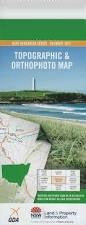
This Topographic Map is produced by the New South Wales Government.
This map is supplied in digital in PDF format, which means it can be printed at home or sent to a professional printer for a 100% scale reproduction.
At this scale, 4cm on this map represents 1km on the ground. A standard map (which is square) covers an area of approximately about 12.5km by 12.5km, with a contour interval of 10m. This map contains natural and constructed features including road and rail infrastructure, vegetation, hydrography, contours, localities and some administrative boundaries.
Toolamba Park Kopi Bloomfield Merle Grove Ascot Vale Coo-Ee Millendale Kia-Ora Yambiana Mawarra Billabar Luluigui Blairathol Canura Somerset Hazeldean Yantara Merribee Myrtle Park Chiswick Park Merrivale Baralong Fairview Gil Guy Hughenden Wilga Park Dunkeld Kurrajong New Chum Hillview Lucknow Blue Tank Blue Bush Hill Bondi Gibbs Moura New Chum Tank North Merribee Channel Round Hill Saltbush Tank Waugh White Tank Yanco Yenda Burnt Hill Garoolgan Patterson Well Barellan Tank