
QLD 6754
QLD 6754
Digital Products: You will receive an email shortly after checkout containing links to download your products.
If you do not receive this email within 30min, please check your Junk / SPAM email folder, prior to contacting us.
Description
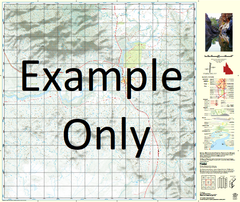
This Topographic Map is produced by the Department of Natural Resources and Mines (DNRM), part of the Queensland Government.
This product is continously updated with the latest information available. New editions are generally published in Oct/Nov each year, however minor updates are constantly being included.
DNRM maps are produced automatically by computers, with minimal human oversight; so some duplication of information and occasional minor cartographic inconsistencies can be found.
The PDF version of this can be printed at home or sent to a professional printer for a 100% scale reproduction.
At this scale, 1cm on this map represents 1km on the ground. A standard map (which is square) covers an area of approximately 54km by 54km, with a contour interval of 20m. This map contains natural and constructed features including road and rail infrastructure, vegetation, hydrography, contours, localities and some administrative boundaries.
Anthony Creek Ardmore Blazan Creek Briar Creek Carbine Creek Cranley Dinner Creek Frimley Horse Creek Jayah Bore Creek Jayah Rocky Creek Jayah Water Facility Kilmeadan Manganese Ridge Oroopo Oroopo Waterhole Pidgeon Creek Pinnacle Knob Plain Creek Riversdale Rufus Creek St Ronans Dry Branch Creek St Ronans Wet Branch Creek Steamboat Hill Sulieman Water Facility Thursley Timothy Creek Wonersh Wonomo Wonomo Waterhole Waverley Middle Pigeon Bore Lower Pigeon Bore Jayah Bore Old Ardmore Bore Pigeon Creek Black Mount Tank Horse Creek Bore Goodwins Bore Ardmore Bore Sulieman Bore Top Split Creek Bore Bottom Split Creek Bore Dry Branch Saint Ronans Creek Rundle Well Dinner Creek Bore Quita Waterhole Kallala Bore QT Kallala Bore