
QLD 6755
QLD 6755
Digital Products: You will receive an email shortly after checkout containing links to download your products.
If you do not receive this email within 30min, please check your Junk / SPAM email folder, prior to contacting us.
Description
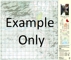
This Topographic Map is produced by the Department of Natural Resources and Mines (DNRM), part of the Queensland Government.
This product is continously updated with the latest information available. New editions are generally published in Oct/Nov each year, however minor updates are constantly being included.
DNRM maps are produced automatically by computers, with minimal human oversight; so some duplication of information and occasional minor cartographic inconsistencies can be found.
The PDF version of this can be printed at home or sent to a professional printer for a 100% scale reproduction.
At this scale, 1cm on this map represents 1km on the ground. A standard map (which is square) covers an area of approximately 54km by 54km, with a contour interval of 20m. This map contains natural and constructed features including road and rail infrastructure, vegetation, hydrography, contours, localities and some administrative boundaries.
Mount Guide Ashover Baslow Black Creek Brampton Crooked Creek Farncombe Farnham Flat Creek Frensham Galah Creek Gidya Creek Hascombe Kahko Kahko Creek Little Galah Creek Nine Mile Creek Oban Oban Water Facility Peters Creek Waverley Mount Woodhouse Yappo Creek Yellow Waterhole Dingo Hole Bore Ascot Bore Yarrawinga Waterhole Bramley Bore Mount Horace Bore Kedron Bore Elorado Bore Gidya Creek Bore Jura Bore Randwick Bore Station Bore Rochdale Home Tank Three Mile Bore Eight Mile Bore Old Six Mile Bore Gorge Bore Williams Dam Woolshed Bore Nine Mile Bore Mosman Well Kahko Bore Pigeon Creek Bore Middle Pigeon Bore