
QLD 6757
QLD 6757
Digital Products: You will receive an email shortly after checkout containing links to download your products.
If you do not receive this email within 30min, please check your Junk / SPAM email folder, prior to contacting us.
Description
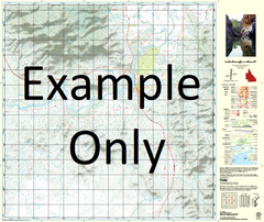
This Topographic Map is produced by the Department of Natural Resources and Mines (DNRM), part of the Queensland Government.
This product is continously updated with the latest information available. New editions are generally published in Oct/Nov each year, however minor updates are constantly being included.
DNRM maps are produced automatically by computers, with minimal human oversight; so some duplication of information and occasional minor cartographic inconsistencies can be found.
The PDF version of this can be printed at home or sent to a professional printer for a 100% scale reproduction.
At this scale, 1cm on this map represents 1km on the ground. A standard map (which is square) covers an area of approximately 54km by 54km, with a contour interval of 20m. This map contains natural and constructed features including road and rail infrastructure, vegetation, hydrography, contours, localities and some administrative boundaries.
Calton Hills Arcas Brahe Burnley Bustard Creek Crooked Creek Eight Mile Creek Forty Eight Mile Water Facility Gilchrist Holmfirth Horse Creek Inca Kennedy Gap Kepler Leander Range Letterbox Creek Lima May Downs Millican Creek Mine Creek Paroo Waterhole Prestbury Sixteen Mile Creek The Valley Waterhole Twenty Nine Mile Water Facility Underilla Creek Valley Water Facility Waggaboonyah Range Wilfred Creek Yelvertoft Top Bullock Paddock Bore Gundiria Bore Naggaboonyah Range Angle Waterhole Twenty Nine Mile Bore Old May Downs