
QLD 6762
QLD 6762
Digital Products: You will receive an email shortly after checkout containing links to download your products.
If you do not receive this email within 30min, please check your Junk / SPAM email folder, prior to contacting us.
Description
This Topographic Map is produced by the Department of Natural Resources and Mines (DNRM), part of the Queensland Government.
This product is continously updated with the latest information available. New editions are generally published in Oct/Nov each year, however minor updates are constantly being included.
DNRM maps are produced automatically by computers, with minimal human oversight; so some duplication of information and occasional minor cartographic inconsistencies can be found.
The PDF version of this can be printed at home or sent to a professional printer for a 100% scale reproduction.
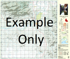
At this scale, 1cm on this map represents 1km on the ground. A standard map (which is square) covers an area of approximately 54km by 54km, with a contour interval of 20m. This map contains natural and constructed features including road and rail infrastructure, vegetation, hydrography, contours, localities and some administrative boundaries.
Agnew Waterhole Atlas Creek Bare Lagoon Barkly River Beames Beames Brook Bow Waterhole Buffalo Creek Burlong Calshot Caseys Creek Caseys Waterhole Cattle Crossing Cockatoo Swamp Cockatoo Waterhole Egilabria Emu Creek Escott Flying Fox Waterhole Gaynor Creek Goose Lagoon Gregory River Hanns Crossing Harrisdale Hawk Nest Lagoon Inner Island Lily Creek Lily Waterhole Marless Lagoon McNelty Creek Nierrina Water Facility One Mile Creek Pendine Shadforth Creek Titchfield Twelve Mile Creek Wattle Creek Wild Horse Creek Wood Pocket Woods Lake Porchester McNeltys Creek Escott Waterhole Lilly Waterhole Henry Creek Teece Camp Lagoon Hawks Nest Lagoon Beamasbrook Elgilabria