
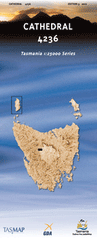
TAS 4236
Cathedral
Digital Products: You will be forwarded a copy of your digital product via email the following business day.There are no automatic download services available for Tasmap digitial products.
Digital Limitations: Please note that the digital version of these maps DO NOT contain borders, legends, scales, etc. Where a product covers multiple areas, each area is provided as a seperate file. These may not be suitable for use as a print product.
Description
This Topographic Map is produced by the Department of Primary Industries, part of the Tasmanian Government.
These maps are an important resource for Government, industry, and the public. They are used for environmental and emergency management, farm planning and mineral exploration. They are also popular for recreational users such as bushwalkers, mountain bike and horse riders.
The PDF version of this can be printed at home or sent to a professional printer for a 100% scale reproduction.
At this scale, 4cm on this map represents 1km on the ground. A standard map (which is square) covers an area of approximately about 12.5km by 12.5km, with a contour interval of 10m. This map contains natural and constructed features including road and rail infrastructure, vegetation, hydrography, contours, localities and some administrative boundaries.
Big Creek Bishop Peak Bishops Mitre Blizzard Plain Boulder Falls Cathedral Falls Cathedral Mountain Chalice Lake Chapter Lake Cloister Lagoon Convent Hill Curate Bluff D'Alton Falls Dean Bluff Fergusson Falls Grail Falls Horeb Falls Jacksons Creek Juno Creek Kia Ora Creek Kia Ora Falls Ladder Creek Ladder Falls Lake Adelaide Lake Ayr Lake Bigfoot Lake Bill Lake Charles Lake Louisa Lake McCoy Lake McFarlane Lake Meston Lake Myrtle Lake Poa Lake Toorah Lees Paddocks Lewis Falls Meribah Falls Moses Creek Mount Doris Mount Massif Mount Pelion East Mount Rogoona Oxley Falls Pelion Gap Pine Hut Plain Pinestone Valley Premier Peak Reedy Lake Richards Creek Snarers Hut Creek Stockyard Creek Survey Creek Tent Tarn Toad Rock Twin Spires Vicar Bluff Wadleys Creek Walls of Jerusalem National Park