
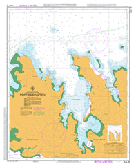
AUS 18
Port Essington
Please note that all charts are nominally folded in half for storage and handling as per the marine industries standard.
If you require an unfolded copy (ie: flat for framing), please select Flat Paper, and we will organise a special print service to accomodate your request.
Description
This official Nautical Chart is produced by the Australian Hydrographic Office, and corrected fortnightly to 'Notice to Marines' by Cairns Charts & Maps. This ensures it remains compliance with Safety of Navigation requirements. This marine chart, or 'sea map', is primarily produced to support the safe navigation of commercial shipping through Australian, Papua New Guinea and Solomon Island waters.
Nautical charts depict the seabed, or bathymetry, using a variety of colours to shade the depth regions. Darker blues indicate shallower water, while light blues and white indicate deeper water. A chart will also show continuous contour lines (at varying intervals depending on the scale of the chart), 'spot depths' across the whole area, as well as different symbols indicating wrecks, shallow rocks and dangers, as well as details on lights, light houses, tides and currents.
For extensive detail on the symbology of nautical charts, the Symbols and Abbreviations used on Admiralty Charts is the definitive reference.
Adam Head Adbanae Alaru Creek Barrow Bay Bedford Head Berkeley Bay Black Point Caiman Creek Cobourg Cobourg Marine Park Coral Bay Coral Reef Curlew Bay Curlew Point Earl River East Bay East Station Point Edwards Point False Turtle Point Garig Gunak Barlu National Park Gumeragi Gunners Quoin Kangaroo Point Kennedy Bay Knocker Bay Kuper Point Lizard Bay Low Point Mangrove Point Mawuwu Creek Meander River Middle Head Midjari Point Minto Head Observation Cliff Orontes Reef Oyster Point Point Sleeman Port Bremer Port Essington Priest Point Record Point Reef Point Saddle Hill Sandy Island No 2 Sandy Island Number 1 Shamrock Bay Silvid Bay Smith Point Spear Point Stewart Point Table Head Turtle Point Vashon Head Victoria Settlement Walford Point Wanaraij Point Wangewanja Cove West Bay West Station Point White Cliff Sandy Island Number 2 Cobourg Peninsula Coburg Peninsula Wangewanga Cove Wanjewanja Cove Silvio Bay