
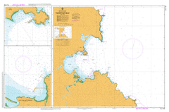
AUS 192
Twofold Bay
Please note that all charts are nominally folded in half for storage and handling as per the marine industries standard.
If you require an unfolded copy (ie: flat for framing), please select Flat Paper, and we will organise a special print service to accomodate your request.
Description
This official Nautical Chart is produced by the Australian Hydrographic Office, and corrected fortnightly to 'Notice to Marines' by Cairns Charts & Maps. This ensures it remains compliance with Safety of Navigation requirements. This marine chart, or 'sea map', is primarily produced to support the safe navigation of commercial shipping through Australian, Papua New Guinea and Solomon Island waters.
Nautical charts depict the seabed, or bathymetry, using a variety of colours to shade the depth regions. Darker blues indicate shallower water, while light blues and white indicate deeper water. A chart will also show continuous contour lines (at varying intervals depending on the scale of the chart), 'spot depths' across the whole area, as well as different symbols indicating wrecks, shallow rocks and dangers, as well as details on lights, light houses, tides and currents.
For extensive detail on the symbology of nautical charts, the Symbols and Abbreviations used on Admiralty Charts is the definitive reference.
Eden Aslings Beach Beermuna Bellbird Creek Bellbird Creek Nature Reserve Bimmil Lookout Bimmil Bimmil Hill Boyd East Boyds Tower Boydtown Boyd Town Boydtown Beach Boyd Town Beach Boydtown Creek Boyd Town Creek Brandy Creek Brandy Creek Beach Brierly Point Point Brierley Browning Hills Bullara Calle Calle Bay Cattle Bay Cochranes Creek Cochranes Flat Cocora Beach Cocora Lagoon Cocora Point Curalo Lagoon Currawulla Beach Davidson Whaling Station Historic Site Denn Creek Eagles Claw Nature Reserve East Boyd Bay East Boyd Town Eden Marine High School Eden Public School Eden Wharf Fisheries Beach Fisheries Creek Fisheries Flat Freshwater Creek George Bass Park Haycock Hill Honeysuckle Point Jews Head Cocora Curalo Lake Currawulla Currawullo Fishery Creek Kiah Kiah Inlet Legges Beach Lennards Island Lookout Point Mangaema Creek Mewstone Rock Moutrys Point Mowarry Mowarry Point Mowtrees Head Munganno Munganno Point Murrumbulga Point Murrumbulga Recreation Reserve Northcote Point North Head Nullica Bay Oman Point Palestine Creek Peisley Park Quandoa Quandoa Point Quarantine Bay Red Point Rixons Beach Rixons Bower Saltwater Creek Seahorse Shoals Snug Cove Torarago Torarago Point Towamba River Twofold Bay Two Mile Creek Wellings Park West Boyd Town Whale Beach Whale Spit Whelans Swamp Worang Point Yallumgo Cove Bungo Bungo Beach Eden Breakwater Kebby Park Bungo Point Bilgalera Point The Eagles Claw Mirare Point Mungora Edrom Terrace Point Ben Boyd Dam Ben Boyd Reservoir Bellbird Eden Marine Technology High School Leather Jacket Bay Bullara Island Mount Robinson Worange Point Worango Yallumgao Cove Weecon Cove East Boyd Cocoln Point Quondoa Point Mungora Point Kiah River Towamba Munganoo Point Upper Kiah Mowwarry Point