
AUS 299
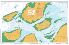
Approaches To Thursday Island
Please note that all charts are nominally folded in half for storage and handling as per the marine industries standard.
If you require an unfolded copy (ie: flat for framing), please select Flat Paper, and we will organise a special print service to accomodate your request.
Description
This official Nautical Chart is produced by the Australian Hydrographic Office, and corrected fortnightly to 'Notice to Marines' by Cairns Charts & Maps. This ensures it remains compliance with Safety of Navigation requirements. This marine chart, or 'sea map', is primarily produced to support the safe navigation of commercial shipping through Australian, Papua New Guinea and Solomon Island waters.
Nautical charts depict the seabed, or bathymetry, using a variety of colours to shade the depth regions. Darker blues indicate shallower water, while light blues and white indicate deeper water. A chart will also show continuous contour lines (at varying intervals depending on the scale of the chart), 'spot depths' across the whole area, as well as different symbols indicating wrecks, shallow rocks and dangers, as well as details on lights, light houses, tides and currents.
For extensive detail on the symbology of nautical charts, the Symbols and Abbreviations used on Admiralty Charts is the definitive reference.
Thursday Island Wasaga Rose Hill Aplin Pass Battery Point Black Rock Brewster Reef Brisbane Rock Cardale Patch Channel Rock Devonshire Rock Ellis Channel Friday Island Friday Passage Ghibber Rock Goods Island Green Hill Greenant Hill Hammond Island Heath Point Hovell Rock Ipili Reef Kapuda Islet Kunai Islet Madge Reef Mecca Reef Milman Hill Muralug Normanby Sound Peile Reef Quoin Point Round Island Smith Point Tamwoy Tessy Head Torres Vivien Point Wai-Weer Islet Webb Point West Wai Weer Reef Round Island Conservation Park Double Hill Bruce Point Wednesday Spit Menmuir Point Sunk Reefs Hammond Islands Keriri Hester Hill Pig Hill Goode Island Palilug Diamond Point Bertie Bay Wanetta Tucker Point Powell Point Hovell Bar West Wai-Weer Reef Kate Point Wai-ben Normandy Sound Kunai Island Wilkie Bank Port Kennedy Thursday Island Harbour Normanby Sound Ledge Pott Point Kiwain Point Madge Reefs Holmes Reef The Gut Bogan Banks