
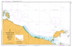
AUS 304
Wellesley Islands To Vanderlin Island
Please note that all charts are nominally folded in half for storage and handling as per the marine industries standard.
If you require an unfolded copy (ie: flat for framing), please select Flat Paper, and we will organise a special print service to accomodate your request.
Description
This official Nautical Chart is produced by the Australian Hydrographic Office, and corrected fortnightly to 'Notice to Marines' by Cairns Charts & Maps. This ensures it remains compliance with Safety of Navigation requirements. This marine chart, or 'sea map', is primarily produced to support the safe navigation of commercial shipping through Australian, Papua New Guinea and Solomon Island waters.
Nautical charts depict the seabed, or bathymetry, using a variety of colours to shade the depth regions. Darker blues indicate shallower water, while light blues and white indicate deeper water. A chart will also show continuous contour lines (at varying intervals depending on the scale of the chart), 'spot depths' across the whole area, as well as different symbols indicating wrecks, shallow rocks and dangers, as well as details on lights, light houses, tides and currents.
For extensive detail on the symbology of nautical charts, the Symbols and Abbreviations used on Admiralty Charts is the definitive reference.
Mornington Gununa Abel Tasman River Addison Channel Alola Islet Anderson Point Ataluma Point Babungi Baker Yard Bald Hill Barbara Cove Barclay Point Barranyi National Park Base Bay Beattie Shoal Beavan Point Big Stinking Lagoon Binmarina Gorge Bluey Creek Bluey Waterhole Brown Islet Bruce Channel Buffalo Yard Bujan Bull Paddock Yard Burulina Waterhole Cabbage Tree Cove Calvert Calvert River Camel Creek Camel Creek Yard Cape Pellew Cape Vanderlin Catfish Yard Centre Channel Charles Point Clarke Bay Clarke Bay Weather Station Clarkson Point Clarkson Point Fishing Camp Clover Shoal Collar Creek Combes Point Conder Point Craufurd Islet Crook River Crown Rock Daisy Islet Danby Shoal Daves Yard David Islet Dead Mans Yard Deadmans Creek Denten Point Dingo Creek Disaster Reef Fantome Point Fat Fellows Creek Five Mile Yard Foelsche River Geranium Bay Goat Point Golden Yard Greenbank Gulch Reef Gunyana Bay Haig And Haig Heriot Reef Hervey Rocks Hobblechain Creek Hobblestrap Hobblestrap Creek Horn Islet Horse Creek Hyde Channel Illida Waterhole Inner Bank Investigator Bay Investigator Point Jean Point Jimmy Islet Johnston Islet Jolly Islet Junction Yard Kangaroo Creek Karns Creek Kedge Point Kiernan Springs Yard Kirkby Shoal Koolfella Creek Lake Eames Lamalooma Yard Law Island Lily Lagoon Linangkarr Rocks Little Island Little Stinking Lagoon Little Vanderlin Island Long Point Long Reef Macassar Bay Manangoora Manangoora Fishing Camp Mariniri Marmarina Lagoons Marsden Shoal Maxwell Point Mc Craggan Creek Mc Craggans Yard Mc Queens Yard Mesley Point Middle Shoal Mimina Mooloowa Moonlight Yard Mountain Creek Mud Bay Murrenginya Island Myoorlka Island Nine Mile Yard Nippers Creek Niwawunala Reef North Hill North Island North Rock Observation Island One Tree Islet Outer Bank Paradice Bay Pearce Islet Pelican Spit Phil Point Photo Creek Photo Yard Piker Creek Piker Springs Potter Deep Pungalina Creek Quince Islet Red Bluff Red Point Redbank Creek Rifle Creek Rifle Creek Yard Robinson River Robinson River Aerodrome Robinson River Health Centre Robinson River School Rock Island Rocky Creek Rocky Island Rocky Point Rocky Yard Ross Point Rubys Creek Running Creek Running Creek Yard Sand Islet Sandfly Island Sandy Creek Sandy Head Schofield Channel Scrutton Lagoon Seven Emu Seven Emu Creek Shark Creek Sharp Stones Point Skeleton Creek Skull Creek Skull Island Small Islet Snake Creek Snake Lagoon Southern Cross Creek Steepcut Rock Stevens Rocks Stockyard Creek Stokes Bay Surprise Creek Symonds Bluff The Gutter Three Hummock Point Train Point Triangular Yard Tucker Bay Turtle Islet Turtle Reef Turton Rock Uguie Ulbara Point Urquhart Islet Van Alphen River Vanderlin Island Vanderlin Rocks Victoria Bay Walker Point Wambarra Islet Wanadjurara Rocks Wandikalarubun Islet Warlubarlula Beach Water Beach Watson Inlet Watson Island Wawinda Islet Waywantha Island Wearyan River Wearyan River Boat Ramp Wearyan River Landing Ground Webe Point Webinger Point Wheatley Islet Whittet Point Willy Islet Winanda Channel Wonmurri Lagoon Wubukabukala Islet Wulaburri Wunakakalijulakinda Point Wundigalla Wurdurla Islet Wuthangka Islet Yangulinyina Yathulwa Islets Yellow Waterhole Yard Yulbara Allen Island Ambleside Andrew Island Appel Channel Archies Creek Arthurs Creek Ballast Creek Bayley Island Bayley Point Beahgoo Island Beche De Mer Bay Beche De Mer Point Beeberr Creek Bendigo Waterhole Beryl Creek Bessie Island Bidgagun Bay Billmahgun Point Bilmagun Point Boogorgun Spring Bountiful Bountiful Islands Bowness Boyorrunga Inlet Brookes Reef Bundella Waterhole Charlie Bush Bay Cliffdale Creek Dalgurge Creek Dalmumeah Creek Dangan Denham Island Dougherty Bay Douglas Island Dubbar Point Dugong River Dungnoreah Point Dwenty Point Eengan Bay Eight Mile Creek Elizabeth Creek Elizabeth River Forsyth Forsyth Island Forsyth Islands Garret Gatgatgerah Creek Gee Wee Creek Gee Wee Point Gerrigroo Point Gilitja Point Gold Creek Golden Waterhole Goojamun Creek Government Bay Government Point Greenaway Point Gum Creek Gumbannge Point Gununa Hall Point Hann Creek Highclere Horse Island Horse Place Creek Horseshoe Island Ivis Island Jidan Marun Jirke Island Jubuneah Point Kendal Kungunmeah River Lagoon Creek Lelkajindi Creek Letter Creek Lingele Point Lingeleah Island Lingnoonganee Island Little Allen Island Lowareah Point Manowar Island Margaret Island Massacre Inlet Meahyawogan Point Midbagar Point Moondalbee Island Mornington Mornington Island Mudgun Point Nalloor Ngawalgeah Point Ngulwonmeah River Nings Waterhole Nithalan Creek Nyuldora Oaktree Point Packsaddle Creek Packsaddle Waterhole Pains Island Parker Point Parker Passmore Creek Patterdale Peacock Lagoon Peacock Waterhole Pisonia Island Porpoise Point Sandalwood Place River Selside Settlement Creek Snapper Point Sydney Island Syrell Creek Teevar Thabugan Point Timber Point Toongoowahgun Inlet Towbulbulan River Troutbeck Ttooldalin Waterhole Tulburrerr Island Tully Inlet Cape Van Diemen Waddagun Waterhole Walbor Inlet Warahbah Point Wardoo Creek Watson Patch Wavar Weediah Bay Wellesley Islands Wentworth Whale Point White Cliff Wonongung Waterhole Woolgunjin Point Wuduganan Creek Wunungun Point Yuwah Point South Wellesley Islands West Wellesley Islands Gangalidda Pearce Island Urquhart Island Pardice Bay Turtle Island Observation Islet David Island Alola Islet Sir Edward Pellew Group Sir Edward Pellew Islands Brown Island Jolly Island Small Island Little Vanderin Island Wonmaree Lagoon Seven Emus Creek Abel Tasman Creek Seven Emus Simpsons Lagoon Turtle Lagoon Brumby Lagoon Eegan Bay Lingnoongangee Island Wallaby Island Halls Point Pisonia Islet Baldy Head Point Giltija Point Ngulwange River Humbug Point Roogorgun Spring Dimareah Bay Dwenty Gubungura Spring Point Ngawalge Point Gee Wee Hopple Strap Creek Gold Cliff Kelly Gap Mornington Mission Mornington Island Mission Station Mornington Mission Station Turtle Islands Wellesley Isles Dockety Bay Andrews Island Schnapper Point Beche de Mer Point Quaker Creek Pack Saddle Creek Francis Island Pasmore Creek Robert Island Yackamunda Waterhole McCarthy Island Buchanan Creek Parker Point