
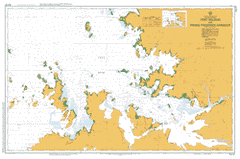
AUS 37
Port Nelson And Prince Frederick Harbour
Please note that all charts are nominally folded in half for storage and handling as per the marine industries standard.
If you require an unfolded copy (ie: flat for framing), please select Flat Paper, and we will organise a special print service to accomodate your request.
Description
This official Nautical Chart is produced by the Australian Hydrographic Office, and corrected fortnightly to 'Notice to Marines' by Cairns Charts & Maps. This ensures it remains compliance with Safety of Navigation requirements. This marine chart, or 'sea map', is primarily produced to support the safe navigation of commercial shipping through Australian, Papua New Guinea and Solomon Island waters.
Nautical charts depict the seabed, or bathymetry, using a variety of colours to shade the depth regions. Darker blues indicate shallower water, while light blues and white indicate deeper water.A chart will also show continuous contour lines (at varying intervals depending on the scale of the chart), 'spot depths' across the whole area, as well as different symbols indicating wrecks, shallow rocks and dangers, as well as details on lights, light houses, tides and currents.
For extensive detail on the symbology of nautical charts, the Symbols and Abbreviations used on Admiralty Charts is the definitive reference.
Anderdon Islands Augereau Island Bat Island Bernouilli Island Bonaparte Island Boongaree Island Cape Brewster Cape Pond Cape Torrens Cape Wellington Careening Bay Coronation Island Coronation Islands Desaix Islands Desfontaines Island Ena Island Fontanes Island Gale Island Glauert Island Grey Island Hardy Point Hunter River Ivy Cove Kartja Island Kumpanapirra Creek Kuringna Lamarck Island Low Rock Mably Island Manning Peak Marun Mitchell Plateau Mount Anderdon Mount Knight Murrara Island Naturalists Beach Naturalists Island Port Nelson Prince Frederick Harbour Roe River Tanpanmirri Island Thais Island Tjungkurakutangari Island Tournefort Island Waring Island Wickham Island York Sound Fontanes Islet Desaix Island Desaix Islet Malby Island Malby Islet Anderdon Islets Mobly Island Bernouill Islet Bat Islet