
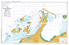
AUS 57
Dampier Archipelago
Please note that all charts are nominally folded in half for storage and handling as per the marine industries standard.
If you require an unfolded copy (ie: flat for framing), please select Flat Paper, and we will organise a special print service to accomodate your request.
Description
This official Nautical Chart is produced by the Australian Hydrographic Office, and corrected fortnightly to 'Notice to Marines' by Cairns Charts & Maps. This ensures it remains compliance with Safety of Navigation requirements. This marine chart, or 'sea map', is primarily produced to support the safe navigation of commercial shipping through Australian, Papua New Guinea and Solomon Island waters.
Nautical charts depict the seabed, or bathymetry, using a variety of colours to shade the depth regions. Darker blues indicate shallower water, while light blues and white indicate deeper water. A chart will also show continuous contour lines (at varying intervals depending on the scale of the chart), 'spot depths' across the whole area, as well as different symbols indicating wrecks, shallow rocks and dangers, as well as details on lights, light houses, tides and currents.
For extensive detail on the symbology of nautical charts, the Symbols and Abbreviations used on Admiralty Charts is the definitive reference.
Dampier Angel Island Angus Reef Anna Beach Bare Rock Big Tree Well Black Hawk Bay Bluff Point Boat Rock Boiler Rock Boomer Passage Brigadier Island Bulgarra Burrup Burrup Peninsula Cape Bruguieres Cape Legendre Channel Islands Channel Reef Chookie Bay Cleaverville Cleaverville Creek Cohen Island Collier Rocks Conflict Reef Conzinc Bay Conzinc Island Courtenay Head Courtenay Shoal Cove Well Cowrie Cove Dampier Archipelago Dampier Primary School David Bay Dockrell Reef Dolphin Island Dolphin Island Nature Reserve Eaglehawk Island East Intercourse Island East Lewis Island East Mid Intercourse Island East Rock Egret Island Elphick Nob Enderby Island Enderby Reef Erikson Bay False Summit Fields Creek Flying Foam Passage Foul Point Georgeff Reefs Gidley Island Goodwyn Island Gordon Point Gum Swamp Gwen Creek Hamersley Channel Hamersley Shoal Hampton Harbour Harbour Mound Hauy Island Haycock Island Hearson Hearson Cove High Point Holden Point Hungerford Bay Illingworth Passage Intercourse Island Jennifer Creek Jurat Reserve Kangaroo Hill Karratha Karratha Aerodrome Karratha Bay Karratha Country Club Karratha Education Support Ctr Karratha Primary School Karratha Senior High School Keast Island Kendrew Island King Bay King Point Lady Nora Island Ledge Point Legendre Island Low Island Madeleine Shoals Malus Islands Marks Point Marney Bay Mawby Island Mermaid Sound Mermaid Strait Miller Rocks Mistaken Island Mount Anketell Mount Burrup Mount Wongama Mulataga Nelson Rocks Nest Head Nickol Bay Nickol River Norbill Bay North West Reefs Parker Point Pearl Rocks Pegs Creek Pemberton Island Phillip Point Point O'Keefe Pueblo Shoal Quartermaine Island Rocky Head Roe Point Roebourne Gap Roly Rock Roo Cove Rosemary Island Rosette Bay Sailfish Reefs Sandy Island Seal Passage Searipple Passage Sharp Peak Shoal Bay Sloping Point South Dixon South East Reef South West Reef South West Rock St Pauls Primary School Station Hill Three Peaks Tidepole Island Tish Point Tish Reef Todd Bay Tozer Island Victoria Rock Walcott Island Watering Cove West Intercourse Island West Lewis Island West Mid Intercourse Island Whalers Bay White Peak Whittaker Island Wilcox Island Withnell Bay Hammersley Shoal Hauy Islet Flying Foam Pass Boat Passage Goodwyn Islet Withnell Bay Terminal North West Reef Philip Point Port Robinson Egret Islet Mistaken Islet Haycock Islet East Middle Intercourse Island South West Reefs Low Islet Sandy Ledge Millars Well