
AUS 602
Approaches To Davis Anchorage
Please note that all charts are nominally folded in half for storage and handling as per the marine industries standard.
If you require an unfolded copy (ie: flat for framing), please select Flat Paper, and we will organise a special print service to accomodate your request.
Description
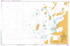
This official Nautical Chart is produced by the Australian Hydrographic Office, and corrected fortnightly to 'Notice to Marines' by Cairns Charts & Maps. This ensures it remains compliance with Safety of Navigation requirements. This marine chart, or 'sea map', is primarily produced to support the safe navigation of commercial shipping through Australian, Papua New Guinea and Solomon Island waters.
Nautical charts depict the seabed, or bathymetry, using a variety of colours to shade the depth regions. Darker blues indicate shallower water, while light blues and white indicate deeper water. A chart will also show continuous contour lines (at varying intervals depending on the scale of the chart), 'spot depths' across the whole area, as well as different symbols indicating wrecks, shallow rocks and dangers, as well as details on lights, light houses, tides and currents.
For extensive detail on the symbology of nautical charts, the Symbols and Abbreviations used on Admiralty Charts is the definitive reference.
Suter Island Old Wallow Lookout Lake Bunning Hill Newman Shoal Torckler Rocks Heidemann Bay Keuken Island Gardner Island Hobby Rocks Anchorage Patch Davis Anchorage O'Gorman Rocks Davis Station Tarn Krat Rocks Anchorage Island Barratt Island Bluff Island Boyd Island Trigwell Island Flutter Island Thala Rock Turner Island Magnetic Island Lake Island Oldroyd Island Waterhouse Island Lugg Island Plough Island Donskiye Islands Warriner Island The Lookout