
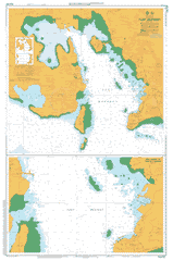
AUS 622
Port Moresby
Please note that all charts are nominally folded in half for storage and handling as per the marine industries standard.
If you require an unfolded copy (ie: flat for framing), please select Flat Paper, and we will organise a special print service to accomodate your request.
Description
This official Nautical Chart is produced by the Australian Hydrographic Office, and corrected fortnightly to 'Notice to Marines' by Cairns Charts & Maps. This ensures it remains compliance with Safety of Navigation requirements. This marine chart, or 'sea map', is primarily produced to support the safe navigation of commercial shipping through Australian, Papua New Guinea and Solomon Island waters.
Nautical charts depict the seabed, or bathymetry, using a variety of colours to shade the depth regions. Darker blues indicate shallower water, while light blues and white indicate deeper water.A chart will also show continuous contour lines (at varying intervals depending on the scale of the chart), 'spot depths' across the whole area, as well as different symbols indicating wrecks, shallow rocks and dangers, as well as details on lights, light houses, tides and currents.
For extensive detail on the symbology of nautical charts, the Symbols and Abbreviations used on Admiralty Charts is the definitive reference.
Walter Bay Verikaka Point Veri Kaka Point Verikaka Vahunabada Tuaguba Hill Port Moresby Tatana Island Tatana Taima Island Taima Taima Islet Sikeri Siker Roku Raku Raven Rock Mount Pullen Port Moresby Harbour Pinnacle Rock Palli Palli Point Pali Pali Point Paga Point Paga Hill Ela Hill Newtown Napa Napa Motukea Island Motu Kea Mavarololo Matao-Oruro Lolorua Island Lolorua Islands Logolu Motu Motu Liberty Patch Konedobu Kanudi Kaevaga Idumava Point Idumava Idubada Idlers Bay Roku Bay Hanuabada Hanuada Gladys Point Gemo Island Hanudamava Island Hanudamawa Island Hanudamua Island Fairfax Harbour Nouga Nouga Nugu Nugu Harbour Esade Motu Motu Esede Motu Motu Elevala Peninsula Elavala Elakurukuru Point Dagnome Cutler Point Coglan Head Boroginimu Bogirohodobi Point Baruni Barume Barune Arakuti Reef Ahearn Point Ugava Hill Digohi Hill Abahua Head Elevala Tanabada Hourata Ubuna Oponogono Ela Beach Crowne Plaza Hotel Port Moresby Poreporena Villages Cargo Terminal Container Wharf