
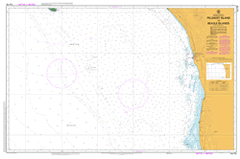
AUS 752
Pelsaert Island To Beagle Islands
Please note that all charts are nominally folded in half for storage and handling as per the marine industries standard.
If you require an unfolded copy (ie: flat for framing), please select Flat Paper, and we will organise a special print service to accomodate your request.
Description
This official Nautical Chart is produced by the Australian Hydrographic Office, and corrected fortnightly to 'Notice to Marines' by Cairns Charts & Maps. This ensures it remains compliance with Safety of Navigation requirements. This marine chart, or 'sea map', is primarily produced to support the safe navigation of commercial shipping through Australian, Papua New Guinea and Solomon Island waters.
Nautical charts depict the seabed, or bathymetry, using a variety of colours to shade the depth regions. Darker blues indicate shallower water, while light blues and white indicate deeper water. A chart will also show continuous contour lines (at varying intervals depending on the scale of the chart), 'spot depths' across the whole area, as well as different symbols indicating wrecks, shallow rocks and dangers, as well as details on lights, light houses, tides and currents.
For extensive detail on the symbology of nautical charts, the Symbols and Abbreviations used on Admiralty Charts is the definitive reference.
Turtle Dove Shoal Dongara 10 Mile Beach 12 Mile Break 16 Mile Swamp 5 Mile Beach 6 Mile Swamp 7 Mile Beach 8 Mile Well 9 Mile Beach Allanooka Allanooka Swamp Arramall Arramall Cave Arramall Lakes Arranoo Arro Lake Arro Well Arrowsmith Arrowsmith Hill Arrowsmith Lake Arrowsmith River Arrowsmith Well Arurine Bay Avoca Barrel Well Beagle Islands Beagle Islands Nature Reserve Beharra Spring Big Breaker Big Horseshoe Reef Bindaree Bonniefield Bookara Bookara Lake Bookara Spring Bounabaja Camp Oven Spring Carsons Beach Casey Corner Casuarina Well Cliff Head Cliff Head Break Clio Bank Coolawarra Crampton Deep Well Dhus Rocks Dog Hole Dongara District High School Dongara Eneabba Mingenew Health Service Dongara Golf Club Double Gee Dummy Break Ejarno Spring Eurangoa Field Lump Flat Rocks Footrot Flats Four J'S Farm Freshwater Point Gadara Gazes Camp Gembira Ginawarra Government Well Green Grove Green Grove Valley Gum Tree Bay Harleys Hole Hawk Reef Head Butts Heelans Chimney Hoolageecarra Well Hunt Gully Hunts Well Huntswell Hurbon Illawong Illyarrie Irradongo Irwin Irwin House Irwin Park Irwin Passage Irwin Plains Irwin Reef Irwin River Jack Reef Jago Jon Jim Island Kingy Bay Knobby Head Koranga Lake Logue Nature Reserve Leander Point Leander Reef Little Freshwater Little Horseshoe Reef Long Reef Low Hill Marloo Mckays Lake Mendara Spring Milo Mindara Mindarra Mondarra Mooratarra Mores Siding Mount Adams Mount Hill Mount Horner Mount Horner Bore Field Mountain Bridge Mug Farm Mumbiba Mungenooka Spring Narkabunda Ngarlingue Spring Ngunkakara Well Nhargo Nhargo Spring North Bank Obawara Old Arro Well Old Faithful Breaker Old Mondarra Otarra Pearlcliffe Pearse Break Pell Bridge Pelsaert Bank Port Denison River Cave Road Board Well Ross-Lyn Plains Saddleworth Sandy Bay Reef Seaspray Beach Seaspray Heights Seaview Shady Grove South Beach South Cliff Head Break South Greenough Springfield Springy Creek Stone Well Strawberry Hill Tabletop The Grange Treacherous Reef Trigg Lump Tuart Park Turtledove Shoal Ularino Hill Walcott Soak Watnaby Well Wattle Downs Wattle Ridge Weedaboondan Well Weelawadgi Cave Weelawadgi Lake Weelawadgi Well Weiro Downs Weizere Whale Point White Point White Point Reef White Tops Windsor Boiler Wondado Springs Woodada Hill Woodada Lake Woodada Well Woodside Wooramurra Wreck Point Wye Farm Wye Spring Yardanogo Nature Reserve Yardanogo Well Yardarino Yardarino Agricultural Area Yardarino Flat Yardarino No. 1 Bore Yardarino No. 2 Bore Crampton Station Crampton Siding Wreck Island Four JS Farm Bookara Station Bokara Yardarino Station Dongarra Clio Reef Leander Point Reef Denison Main Passage Mount Lefroy Roads Board Well Pelsart Bank Fresh Water Point One Bush Hill Beagle Islets Eneabba Creek Eneabba Gully