
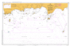
AUS 763
Cape Le Grand To Cape Pasley
Please note that all charts are nominally folded in half for storage and handling as per the marine industries standard.
If you require an unfolded copy (ie: flat for framing), please select Flat Paper, and we will organise a special print service to accomodate your request.
Description
This official Nautical Chart is produced by the Australian Hydrographic Office, and corrected fortnightly to 'Notice to Marines' by Cairns Charts & Maps. This ensures it remains compliance with Safety of Navigation requirements. This marine chart, or 'sea map', is primarily produced to support the safe navigation of commercial shipping through Australian, Papua New Guinea and Solomon Island waters.
Nautical charts depict the seabed, or bathymetry, using a variety of colours to shade the depth regions. Darker blues indicate shallower water, while light blues and white indicate deeper water.A chart will also show continuous contour lines (at varying intervals depending on the scale of the chart), 'spot depths' across the whole area, as well as different symbols indicating wrecks, shallow rocks and dangers, as well as details on lights, light houses, tides and currents.
For extensive detail on the symbology of nautical charts, the Symbols and Abbreviations used on Admiralty Charts is the definitive reference.
Adina Alexander Bay Alexander Hill Alexander Point Alexander River Andrews Point Archdeacon Island Archipelago of the Recherche Arid Bay Arid Island Arid Strait Austin Bank Barely Island Barrier Anchorage Barrier Island Baudin Peak Bay Rock Bearing Rock Beaumont Island Belches Reefs Belinda Beach Belinup Hill Bellinger Island Ben Island Black Boy Creek Black Rock Blind Rocks Boolenup Lake Boulder Hill Boyatup Boyatup Swamp Brewis Island Broomstick Hill Broughton Island Brown Bay Cabbykail Creek Cabbykail Well Calothamnus Point Campbell-Taylor Group Cap Island Cape Arid Cape Arid Creek Cape Le Grand Cape Le Grand National Park Cape Pasley Cape Pillar Rock Capewelluck Spring Carnigup Hill Cave Island Chating Yagenup Cheetup Hill Cheetup Lake Chester Reef Cheyne Point Cliff Island Cloud Island Cluster Rock Cooper Island Cormorant Cove Cornijup Cornwall Island Coronet Hill Coverdale Cove Creak Island Dailey Island Dailey River Dalrymple Rock Dampier Rock Darling Shoal Dicken Reef Disphyma Point Dodd Rock Dome Island Douglas Island Draper Island Duchess Downs Duke Creek Duke of Orleans Duke of Orleans Bay Dunn Rocks Dunns Escape Rock Ferguson Reefs Fern Creek Finch Shoal Finger Island Flinders Peak Foam Rocks Forrest Island Free Island French Reef Frenchman Peak Gardner Rock George Island Gerbryn Gerby Glennie Island Godman Island Goose Island Goose Island Bay Gould Island Grace Shoal Gulch Island Hammer Head Harlequin Island Hasler Island Hastings Island Hawes Hill Hellfire Bay High Island Hope Island Hugo Island Hull Island Inshore Island Jenamullup Creek Jimberlana West John Island Kennedy Beach Kennedy Creek Kermadec Island Kermadec Rocks Kimberley Island La Perouse Rock Lake Hillier Langvale Libke Island Lichen Island Limestone Bay Lorraine Island Lucky Bay Mackenzie Island Mallee Maletup Manicom Island Marbellup Creek Marbellup Hill Marlbemup Hill Mart Islands Mart Rock Marylands Matthew Rock Menbinup Spring Merivale Merivale Farm Middle Island Miles Island Mississippi Hill Mississippi Point Mississippi Reefs Mondrain Island Moonginettee Mortup Hill Mount Arid Mount Belches Mount Hawes Mount Le Grand Mount Merivale Mount Pasley Mungliginup Creek Mungliginup Hill Mungliginup Rockhole Nares Island New Island North East Point North Twin Peak Island North West Point Oceanview Farms Oink N Baa Outtrim Reef Owen Island Palmer Reef Pasco Island Pasley Island Pavement Rock Peak Downs Pearce Rock Pearson Islands Penguin Rock Point Jedacorrudup Pollock Reef Pratt Barlow Reefs Ram Island Rawson Reef Recherche Archipelago Nature Reserve Recherche Rock Right Whale Rock Rob Island Rossiter Bay Roy Island Ruby Island Rundle Patch Russell Rock Saddleback Hill Sail Rock Sailor Rock Salisbury Island Sandy Bight Scatterbreak Reef Share Reef Skink Island Slipper Island South East Islands South East Point South Twin Peak Island South West Point Spray Reef Station Island Stewart Reef Stockyard Creek Stokes Bank Sulphur Reefs Table Island Tagon Harbour Tagon Point Tagon Reef Tagon Rock Tarblong Lake Taylor Boat Harbour Taylor Island The Duke The Valley Thistle Cove Thomas River Tizard Island Tory Islands Trodd Bank Tunney Island Twin Rocks Victoria Harbour Walker Reef Ward Bank Weanerjungup Creek Westall Island Wharton Wharton Beach Wharton Island Whistling Rock Wickham Island Wininyup Woodup Swamp Yokinup Bay York Islands York Rock Yungarup Hill Carncup Hill Coolinup Swamp Boyadup Yerangatup Lake Tarblong Belinup Marlebemup Hill Cheetup Swamp Blackboy Creek Tagon Bay Malle Maletup Well Bellinger Islands Capewellduck Springs Capewulluck Springs Bens Island Yangarup Hill Point Jeadacorrudup Salt Creek Frenchmans Peak Weamerjimgup Creek Weamerjungup Creek Weanenjungup Creek Cape Paseley Belches Reef Mandooburnup Mississippi Bay Twin Peak Islands Twin Peaks Marts Island Cape Le Grande Wedge Island Douglas Islands Round Island Pearson Island LaPerouse Rock South East Isles South East Island