
AUS 820
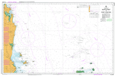
North Reef To Port Clinton
Please note that all charts are nominally folded in half for storage and handling as per the marine industries standard.
If you require an unfolded copy (ie: flat for framing), please select Flat Paper, and we will organise a special print service to accomodate your request.
Description
This official Nautical Chart is produced by the Australian Hydrographic Office, and corrected fortnightly to 'Notice to Marines' by Cairns Charts & Maps. This ensures it remains compliance with Safety of Navigation requirements. This marine chart, or 'sea map', is primarily produced to support the safe navigation of commercial shipping through Australian, Papua New Guinea and Solomon Island waters.
Nautical charts depict the seabed, or bathymetry, using a variety of colours to shade the depth regions. Darker blues indicate shallower water, while light blues and white indicate deeper water. A chart will also show continuous contour lines (at varying intervals depending on the scale of the chart), 'spot depths' across the whole area, as well as different symbols indicating wrecks, shallow rocks and dangers, as well as details on lights, light houses, tides and currents.
For extensive detail on the symbology of nautical charts, the Symbols and Abbreviations used on Admiralty Charts is the definitive reference.
Keiver Rangle Wood Calavalle Tarra Nerang Palm Park Maryvale Svendsen Cawarral Emu Park Yeppoon Bangalee Barmaryee Kinka Mulambin Adelaide Park Arthurs Point Mount Atherton Bald Rock Mount Barmoya Barren Island Bartletts Creek Bayfield Lake Bell Big Fork Creek Black Creek Black Rock Blacksoil Gully Bluff Point Bluff Rock Bondoola Boulder Gully Brampton Creek Brew Shoal Broomfield Reef Brumms Cove Bullock Point Byfield Creek Byfield State Forest Cabby Creek Camp Gully Canton Creek Capricorn Coast Capsize Gully Castle Bellas Causeway Lake Mount Chalmers Cliff Point Clinton Lowland Cape Clinton Cocoanut Point Colcarra Creek Colcarra Range Colcarra Rock Conical Rocks Considine Bay Constitution Hill Cooberrie Cooee Bay Coorooman Coorooman Creek Corduroy Creek Corio Corio Bay Corroboree Island Cowan Creek Creek Rock Delcomyn Island Diamond Creek Dismal Swamp Divided Island Dobbyn Waterhole Dome Island Double Head Double Rock Douglas Shoal East Creek Egg Rock Emu Point Entrance Island Entrance Rocks Fairview Gully Farnborough Fig Tree Creek Fish Rock Fisherman Beach Fishermans Bay Fishing Creek Five Rocks Five Rocks Beach Flat Island Flinders Watering Gully Mount Flinders Freshwater Bay Mount Gibralter Goodwin Shoal Grays Hill Great Keppel Island Greenslopes Inlet Greenslopes Point Guthrie Shoal Haberfield Shoal Halfway Island Hannah Rock Hewittville Holtness Point Horse Camp Spur Humpy Island Innamincka Shoal Inner Head Johnson Patch Kemp Beach Keppel Keppel Islands Keppel Outlook Kinka Beach Lammermoor Beach Launch Rocks Light Me Pipe Gap Lisa Jane Shoals Little Corio Bay Man And Wife Rocks Manifold Manifold Hills Cape Manifold Maryvale Mountain Miall Island Middle Island Monkey Point Mother Macgregor Island Mountain View Mulambin Beach Mulambin Creek Nine Mile Beach Nob Creek North East Point North Keppel North Keppel Island North Reef Island North West Island Nortons Creek Oaky Creek Observation Rock Outer Rocks Palm Creek Pandanus Cove Panorama Point Pearl Bay Pelican Island Pelican Rock Peaked Island Perforated Point Pinnacle Point Pistol Gap Plain Creek Polka Creek Port Clinton Pulleyup Creek Pumpkin Island Quoin Island Ranken Island Rocky Point Ross Creek Rosslyn Rosslyn Head Round Island Round Rock Samuel Hill Sandy Creek Sandy Point Shoal Bay Shoalwater Creek Single Rock Sloping Island Solitude Creek Mount Solitude South Arm Split Island Spring Creek Spring Head Station Creek Statue Bay Statue Rock Mount Steven Stockyard Point Stony Creek Stringybark Creek Sykes Rock Tanby Tanby Point Tea Tree Creek Tea-Tree Creek The Blue Knobs The Child The Peaks The Three Rivers Tryon Island Twenty Mile Creek Two Brothers Valentine Creek Water Park Water Park Creek Water Park Point Wave Point Wedge Island West Flat West Hill West Point West Point Head West Water Mount Wheeler Wilson Island Woodlands Wreck Point Yellow Gully Yeppoon Creek Yeppoon Inlet Zilzie Point Rosslyn Bay Byfield National Park Keppel Bay Islands National Park Keppel Bay Islands National Park Scientific Barlows Hill Zilzie Woodbury Weerriba The Keppels Taroomball Taranganba Stockyard Livingstone Shire Pacific Heights Meikleville Hill Hidden Valley Inverness Lammermoor Causeway Lake Conservation Park Five Rocks Conservation Park Pleasant Island Capricorn Coast National Park Spit Island Mount Gibraltar West Water Head Port Bowen Black Rock Island South Arm Port Clinton Karamea Bank Peaked Islet Peak Island Perforated Island Flat Islet Samuels Hill Barcoo Bank Byfield Moresby Bank Edgell Bank Mount Maryvale Blue Nobs Blue Knobs Bungundarra Outer Rock Man and Wife Rocks Kepple Isles First Lump North Reef Cockscomb Hill Tryon Islet Coowonga Hedlow Creek Wilson Islet