
NSW 7233
Redan
Digital Products: You will receive an email shortly after checkout containing links to download your products.
If you do not receive this email within 30min, please check your Junk / SPAM email folder, prior to contacting us.
Description
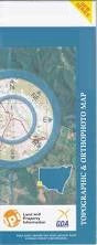
This Topographic Map is produced by the New South Wales Government.
This map is supplied in digital in PDF format, which means it can be printed at home or sent to a professional printer for a 100% scale reproduction.
At this scale, 1cm on this map represents 1km on the ground. A standard map (which is square) covers an area of approximately 54km by 54km, with a contour interval of 20m. This map contains natural and constructed features including road and rail infrastructure, vegetation, hydrography, contours, localities and some administrative boundaries.
Quartz Reef The Springs Farmcote Munka Eureka Huonville Mulculca Redan Kanbara Eaglehawk Langwell Aldborough Tank Darling Farmcoat Tank Horse Lake or Kinalung Kinalung Native Dog Creek Pine Creek Quondong Qyandong Rantyga Creek Redan Creek Rockwell Creek Seventeen Mile Creek Stephens Creek Tank Wendi Wire Yards Creek Caari Mundybah Rantyga Aldborough Barrier Coonbaralla Farmcoat Narran Sebastopol Stratford Tandora Miners Arms Hotel Rockwell Mulgulga Quondong Hotel Kambara