
NSW 8724-3N
Bukalong
Digital Products: You will receive an email shortly after checkout containing links to download your products.
If you do not receive this email within 30min, please check your Junk / SPAM email folder, prior to contacting us.
Description
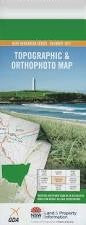
This Topographic Map is produced by the New South Wales Government.
This map is supplied in digital in PDF format, which means it can be printed at home or sent to a professional printer for a 100% scale reproduction.
At this scale, 4cm on this map represents 1km on the ground. A standard map (which is square) covers an area of approximately about 12.5km by 12.5km, with a contour interval of 10m. This map contains natural and constructed features including road and rail infrastructure, vegetation, hydrography, contours, localities and some administrative boundaries.
Back Creek Bedding Ground Bobbys Gully Black Spring Creek Brugolong Creek Bukalong Bukalong Creek Bukalong Railway Station Caissons Creek Cambalong Cambalong Gorge Chisholms Creek Dairy Station Creek Gunningrah Haydens Spring Creek Caissons Gully Gunninggrach Gunning Reach Kirbys Creek Lambing Gully Lambins Flat Merriangaah Merriangaah Peak Needles Creek Pickerings Peak Mount Piper Mount Rix Slaughter House Creek Stoney Gully Stony Gully Walkers Creek Walkers Gully Dry Plain Creek Fattening Paddock Creek Pig Gully Palarang Bukalong Downs Gunning Grach Willowvale Bukalong Station Kuringai Red Cliff Burnima