
NSW 8733-S
Goolma
Digital Products: You will receive an email shortly after checkout containing links to download your products.
If you do not receive this email within 30min, please check your Junk / SPAM email folder, prior to contacting us.
Description
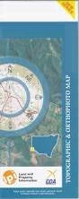
This Topographic Map is produced by the New South Wales Government.
This map is supplied in digital in PDF format, which means it can be printed at home or sent to a professional printer for a 100% scale reproduction.
At this scale, 2cm on this map represents 1km on the ground. A standard map (which is square) covers an area of approximately about 25km by 25km, with a contour interval of 10m. This map contains natural and constructed features including road and rail infrastructure, vegetation, hydrography, contours, localities and some administrative boundaries.
Taranah Aussies Gully Apple Flat Gully Annies Rock Ade Creek Baylys Creek Baylys Gully Ben Buckley Creek Left Hand of Ben Buckley Creek Ben Buckley Hill Beryl Bodangora Blue Biddy Blue Biddy Mountain Blind Creek Biraganbil Bodangora Creek Mount Bodangora Box Gum and Apple Flat Branch of Rats Castle Creek Californian Gully Carberry Cherry Tree Ridge Cobra Congudang Crooked Creek Crowirs Creek Dapper Nature Reserve Dead Horse Creek Fobbys Gully Fords Creek Frenchmans Gully Galambine Gillinghall Golman Gully Goodiman Goodiman Creek Goolma Goolma Creek Goolma Public School Grassy Creek Guntawang Guroba Guroba Creek Hillcroft Jocks Creek Cherry Tree Range Crowics Creek Crowies Creek Cudgebegong Creek Dapper State Forest Dead Horse Gully Mount Emiguyley Fobbys Springs Fromes Creek Public School The Gap Gilling Hall Gollan Public School Goolygowdra or Laheys Creek Grassy Gully Head of Mitchell Creek High Peak Lambing Hill Lincoln Little Nullan Creek Long Creek Long Gully Lower Piambong Mebul Mebul Creek Mitchell Mollys Creek Mollys Mountain Native Dog Creek Nobby Nobby Hill Nuggetty Gully Oaky Creek Piambong Piambong Creek Pig and Whistle Creek The Pinch The Pinnacle Prospect Creek Puggoon Creek and Goodiman Creek Puggoon Rats Castle Rats Castle Creek Ratscastle Creek Rayners Creek Reids Creek Rouse Roweth Ruins Creek Sandy Creek Sheep Station Gully Spicers Creek Spicers Creek Public School Spicers Pinnacle Spring Creek Spring Ridge Spring Ridge Gap Starlight Gully Stoney Creek Stony Creek Tuckers Gully Tuckland Twelve Mile Two Mile Flat Two Mile Flat Creek Uamby Creek Mount Umagarlee Umbrella Gully Umby Creek Village of Warburton Warradugga Creek Waterholes Creek Wiadere Wondaby Worobil Wuuluman Yarrobil Yarrobil State Forest Yellow Gully Bun Buckley Bun Buckley Creek Left Hand of Bun Buckley Creek Dirt Hole Creek Drill Creek Driell Creek Drill Creek Public School Bungiebomar Bungiebomar Creek Bungie Creek Ben Buckley Gollan Klondyke Montaza Buniebomar Creek Slapdash Creek Puggoon Creek Mountain View Warburton Glenlee