
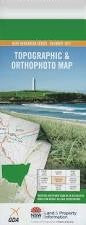
NSW 9030-3S
Warragamba
Digital Products: You will receive an email shortly after checkout containing links to download your products.
If you do not receive this email within 30min, please check your Junk / SPAM email folder, prior to contacting us.
Description
This Topographic Map is produced by the New South Wales Government.
This map is supplied in digital in PDF format, which means it can be printed at home or sent to a professional printer for a 100% scale reproduction.
At this scale, 4cm on this map represents 1km on the ground. A standard map (which is square) covers an area of approximately about 12.5km by 12.5km, with a contour interval of 10m. This map contains natural and constructed features including road and rail infrastructure, vegetation, hydrography, contours, localities and some administrative boundaries.
Pemberton Ridgehaven Hazelwood Vicarys Winery Orana Iona Josma Nepean Waters Gliniffer Park Shipton Le Chapeau Beverina Luddenham Silverdale Warragamba Anschau Badgery Creek Park Badgerys Creek Public School Badgerys Creek Bardwell Creek Bardwell Gully Batts Hollow Bents Basin Bents Basin State Conservation Area Big Crater Creek Big Crater Ridge Birling Braeburn Bringelly Bringelly Creek Bringelly Public School Campbells Ford Clemsons Creek Cobbitty Creek Cobbitty Cook Cut Hill Duncans Creek Eagle Creek East Warragamba Wall Forest Hill Forest Hill Creek Freds Lookout George Park Grays Folly Creek Greendale Jerrys Creek Dark Gully Eastern Branch Henry George Park Hughes Creek Linns Hill Lowes Creek Luddenham Public School Megarritys Creek Middle Creek Middle Gully Monkey Creek Moore Creek Moore Gully Mountain Lowry Creek Oran Park Paddys Swamp Pemberton Creek Pemberton Gully Ravenswood Ripple Sales Park Scotcheys Creek Scotts Hill Sheep Station Creek South Warragamba Wall Spring Creek Sunrise Sunrise Hill Thompsons Creek Warragamba Dam Warragamba Dam Public School Warragamba Public School Warragamba River Wattle Creek Weromba Werombi Werriberri Western Branch Wonga Creek Wonga Gully Bushrangers Cave Bushrangers Creek Caleys Lookout Werriberri Creek Gulguer Nature Reserve Westwood Bringelly Recreation Reserve Freeburn Park Lee Park Scott Memorial Park